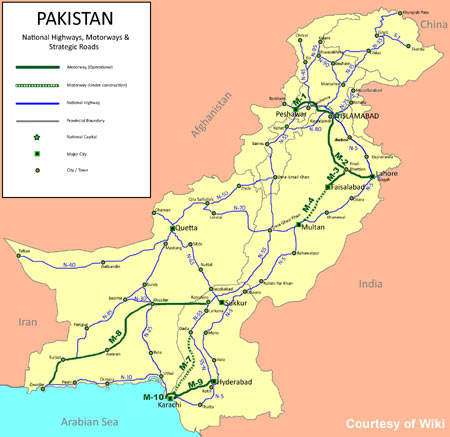
A debate has been going on amongst political leaders, social media, civil society and veterans regarding the CPEC route. The controversy has set in after some maps were displayed showing the route passing through Lahore. To add to the confusion some of the PML-N ministers, mostly kept ignorant by their masters, said that it was a Chinese requirement to utilize a well set route.
The concept of an economic corridor when implemented has tremendous potential for economic development of the region it passes through. The establishment of industry, services, development of mutual trade, commerce and tourism etc. will give a big boost to the fledgling economy of the region. All countries stand to gain meaningfully by the Special Economic Zones (SEZ) specially set along the corridor for this purposes. The CPEC will be of tremendous benefit not only to Pakistan but all countries of the region particularly Afghanistan Central Asian States even India subject to it improving its relations and image in the region..
An attempt is being made to discuss the options available for CPEC, their advantages, disadvantages and suggest a workable solution.
Let us first examine the present workable alternates available.
Route A: Gwadar-Ratodero-Sukkur-Bahawalpur-Lahore-Islamabad- Havelian. Existing along the GT road and motorways it has well developed roads and railway systems by Asian standards. It passes through densely populated areas of both Sindh and Punjab. This route is passing through the most developed agricultural and industrial belt of Pakistan. Any land required for establishment of industry or services for provision to CPEC would need to be taken out of intensive agricultural usage.
This option stands to significantly benefit India as and when allowed to trade through Pakistan.
Route B: It follows the same alignment upto Sukkur, thereafter it goes along the Indus Highway upto Dera Ismail Khan, thence to Mianwali, Havelian and onwards. Presently not as well developed as Route A, but existing road and railway arteries can be developed without much effort. It is backed up by railway track from Sukkur (in fact Shahdadkot) to Havelian which could to be further upgraded. Large tracts of lands are available in sparsely populated barani areas of DGK, DIK and along the MM Road in Thal Desert for establishment of industry and services sector. It is also shorter than Route A. Passing through mostly poor and under-developed areas will be catalyst for development in mid-riff of Pakistan.
Route C: Gawadar-Mastung-Quetta-Zhob-DIK-Kohat- Havelian.
- It is the least developed of all these options. Due to continued neglect, mishandling and ill-treatment of local population some areas suffer, particularly in Makran that suffers from low intensity insurgency. It looks as if Chinese investors have misgivings on our ability to bring peace and tranquility in the insurgency affected area to carry out any major investments for development. It does have sufficient spaces available all along its passage for establishment of industry and development of services sector.
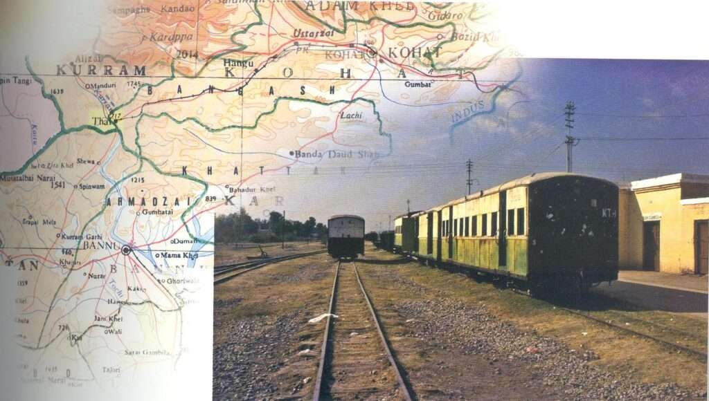
- Gwadar-Quetta-Zhob-Bannu-Kohat Rail Link: Along this route there is a requirement to construct railway track from Gwadar to Mastung with a link going to Khuzdar-Shahdadkot. This railway line should be further re-laid to Zhob, then extended from there to link it with existing railway tracts in KPK. The Havelian to Gwadar/Taftan link coupled with Railway’s mini dry ports will give a jump start to tremendous amount of economic activity in the Trans Indus belt. The existing un-utilized/abandoned rail tracks may be upgraded to broad gauge. The construction of new railway tracks where not existing should be entrusted to the FWO to complete it on war footings. Present situation of railway tracks is as under:

a. Nowshera – Kohat (Babri Banda) 30 miles not existing
b. Kohat – Thal (narrow gauge abandoned) existing-
c. Thal–Bannu-40 miles not existing
d. Bannu–Tank (narrow gauge abandoned) existing-
e. Tank–Zhob-100 miles not existing
The best time to construct this railway and road link was at the beginning of ‘Operation Enduring Freedom’. The Americans had brought a huge floating dock to Pasni to unload their supplies from their cargo ships and airlift these to Afghanistan. That was an ideal time to ask them to foot the bill for a dedicated communication provision for their supplies. Subsequent availability of Karachi and Bin Qasim Ports for off loading and movement of this container traffic upcountry not only wrecked the Pak communication system but also caused numerous other problems including attacks on their warehouses and containers. Gen Musharraf should have bargained and got this rail/road network constructed. US would have gladly paid for Pasni to Torkham Railway and road link.
Laterals/Feeders: Along with North-South laterals there is a strong requirement to strengthen the feeders to these laterals. These feeder communication systems will link the CPEC to communications links with Iran, Turkmenistan, Afghanistan, Uzbekistan, Tajikistan and even India. Some of these feeders recommended to be upgraded are:
- Iskashem (Tajikistan)-Dorah Pass (Afghan-Pak border)-Chitral KKH.
- Lahore-Jhang-DIK-Ghulam Khan- Khost (Afghanistan)
- Multan-Loralai-Quetta-Chaman-Kandhar
Recommendations
Having examined all options we come to the conclusion that Route A being fully developed, passing through densely populated areas and the main agricultural heartland of Pakistan has comparatively little potential for development and establishment of large scale industry and services sector. On the other hand Route-C has the maximum potential to grow and bring in development to a hitherto grossly neglected part of Pakistan. It is visualized that industrial-cum-services zones interspersed on the Corridor Routes will be creating large scale jobs and livelihood.
This Route also integrates those areas of Pakistan which have long remained underdeveloped, deprived of facilities and neglected. It will also be an influencing factor of better enforcement of law and order. Strategically this axis is mostly outside the range of Indian air force in case of war. While keeping the onus of maximum development on Route C, a biaxial approach can be adopted by alongside development of midrift axis that is Route B.
Pakistan should be prepared to keep its own interests paramount and develop Route C on its own in case the Chinese have any misgivings for this Route.


